I’ve always had an appreciation for Americana. Maybe it has something to do with my romantic nature, or the old-fashioned westerns and Hollywood movies that I used to watch as a child. Maybe it is because, as a Brit, America’s relatively short history fascinates me. After all, I grew up in a country whose origin came about after Anglo-Saxon kingdoms unified in the 10th century. Either way, I jumped at the chance to pack up my family and travel by RV across western and central Arizona via America’s historic Route 66.
Established in 1926, and stretching nearly 2,500 miles, Route 66 has been called many names over the years, including the Mother Road and the Main Street of America. Back in the day, it was a way for Americans to hit the road between Chicago and Los Angeles. But the two-lane highway became much more than a means to get from point A to point B. It symbolized the epitome of American road travel. It represented a time of exploration and freedom, independence and discovery. A time when families, like mine, would load up the kids in search of a quintessential road trip adventure.
Today, Arizona’s stretch of Route 66 spans more than 250 drivable miles. Most of it follows Interstate 40 – the road that ultimately replaced the Mother Road in 1984. The impact on the small towns connected by Route 66 was profound at that time. In fact, it nearly led to their demise as businesses closed and folks moved away due to lack of traffic.
However, thanks to the tireless work of a group of volunteers in Seligman, Route 66 is now designated as an Arizona Historic Road. Not to mention a National Scenic Byway. Thankfully each town that it connects does its part to showcase their part in American history. The result is a pilgrimage that offers not just a glimpse into Route 66’s glory days, but also a better understanding of what life used to be like for indigenous people in the area.
My family’s 6-day Arizona adventure began once we crossed over the Colorado River, from Southern California, into Arizona. In this post I’ll share our route and the stops we made along the way. I hope it provides inspiration as you map out your own Route 66 road trip.
Oatman
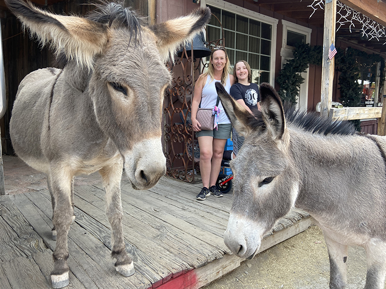
Walking the ¼ mile or so of main street in Oatman reminded me of Virginia City in Nevada. You feel like you’ve stepped back in time to the early 1900’s. Today, this tiny town still has all the characteristics of an old goldrush boomtown, even though mining operations ended here in 1941 when America joined World War II.
But what really makes Oatman unique is the wild burros that have free reign over the town. Said to be direct descendants of the burros that were the backbone of early mining operations, these small donkeys share the streets, sidewalks, and even shop entryways with visitors and residents alike. Super docile, they provide entertainment – not to mention Instagram worthy pictures. You can even feed them special burro pellets. But don’t give the young burros, with stickers on their foreheads, anything to eat.
Aside from the burros there are a couple of attractions worthy of a visit. These include an old mine shaft, and a jail dating back to 1936. The Oatman Hotel is also a great spot for some ice cream. Built in 1902, it is the oldest structure in town. While you are enjoying your tasty treat, admire their massive dollar bill wall, and check out the Clark Gable honeymoon suite. Lastly, if you time your visit to Oatman right, you can witness a gun fight reenactment in the street. Shows typically happen Thursday through Sunday at 1:30 pm.
Sitegreaves Pass and the Goldfish Pond
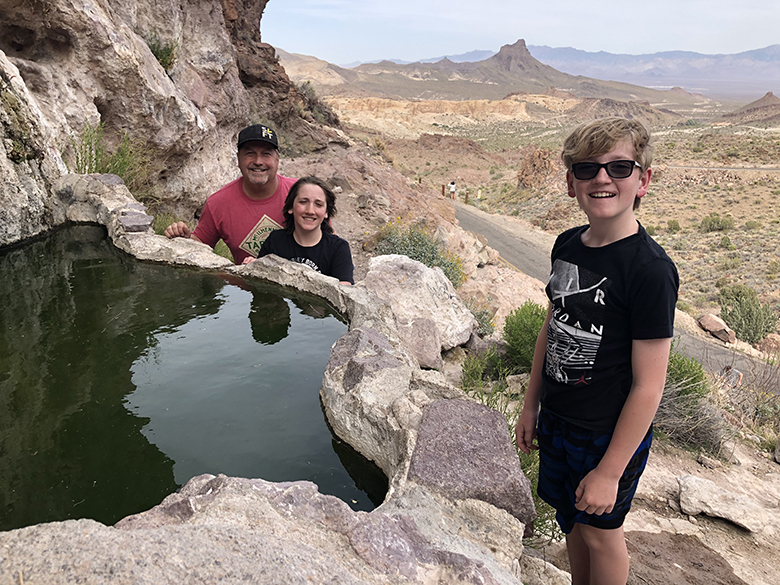
This is something you won’t find in any guidebook. However, it is somewhere where your pint sized mini-me may want to stop. Sitegreaves Pass is said to be the most intimidating section of Arizona’s Route 66. This is because of its steep grades, hairpin curves and drop offs. There is even a sign in Oatman that congratulates travelers (journeying west) for surviving the pass. Personally, I didn’t find it that bad. But I wasn’t driving. Anyway, I digress.
About 5 miles east of Oatman, just over the Sitegreaves Pass, there is a turnout right after mile marker 30. If you park your car and look behind you, there is a stone staircase that leads you up to a tiny pond that is full of little orange goldfish. The water is fed by Shaffer Spring. The stark contrast of this unexpected habitat amidst the rugged and mountainous views is quite striking. And, for kids, they feel like they’ve discovered a secret treasure.
Cool Springs
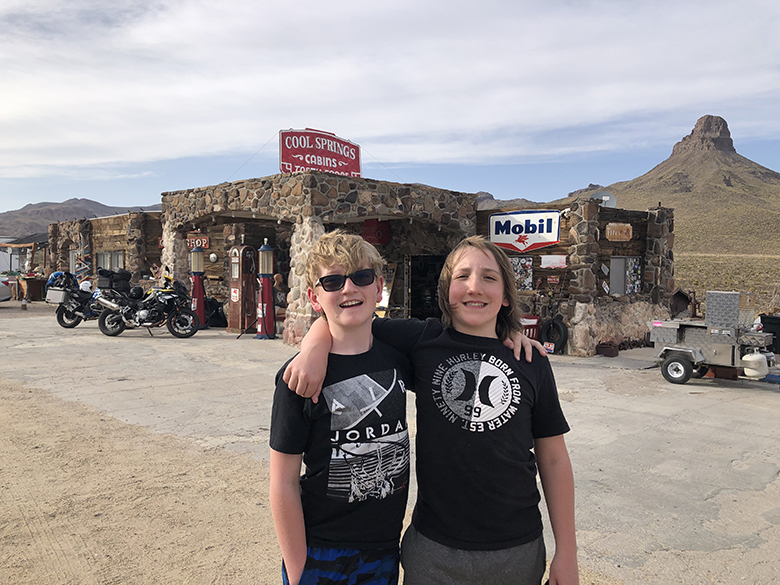
Cool Springs Station sits all alone on a desolate stretch of Route 66, surrounded by nothing but desert. People say that the property was once the inspiration behind the fictitious town of Radiator Springs in Pixar’s animated movie “Cars”. While the film’s director, John Lasseter, did get ideas for the Cars storyline in nearby Seligman, I have a feeling the movie’s connection with Cool Springs may be an urban legend.
What I do know is that Cool Springs Station is a love-story, thanks to a painstaking renovation from a man called Ned Leuchtner. Even its sign is an exact replica or the original neon. In its heyday, Cool Springs Station was the place where weary travelers would stop before making the climb up Gold Hill Road and over Sitegreaves Pass. It was a place for them to gas up, check their oil and water, grab something to eat, and even stay the night.
Now the property serves as a gift shop that offers Route 66 souvenirs and Cool Springs memorabilia. If nothing else, it is worth patronizing as proceeds help support the rebuilding of Cool Springs for future generations.
Kingman
As a bustling city, Kingman is very different from the wilderness to its west. Known as “The Heart of Historic Route 66,” because it has the longest remaining preserved stretch of Route 66 highway, it is easy to picture it as a heart pumping out eager travelers.
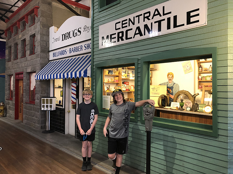
Your kids will thrill at the vintage cars that line the streets. They will also likely beg you to try out the 50’s inspired diner called Mr. D’z, which serves great milkshakes. Yet Kingman’s best attraction is the Historic Route 66 Museum that sits just across the road from D’z. It offers the perfect blend of information, photographs, dioramas, and murals. My boys loved seeing the visual recreation of what a street would have looked like during Route 66’s prime years. And the extensive electric car display downstairs was an unexpected surprise that had them spellbound. They couldn’t decide which was cooler: the bullet racecar, or the golf cart with its own sink.
Just down the road, a block away, is the Mohave Museum of History and Arts. Here you can learn about Native American history, mining history, trains and other topics relevant to the area. Best of all your admission to the Historic Route 66 Museum also gets you entry into the Mohave Museum.
Peach Springs
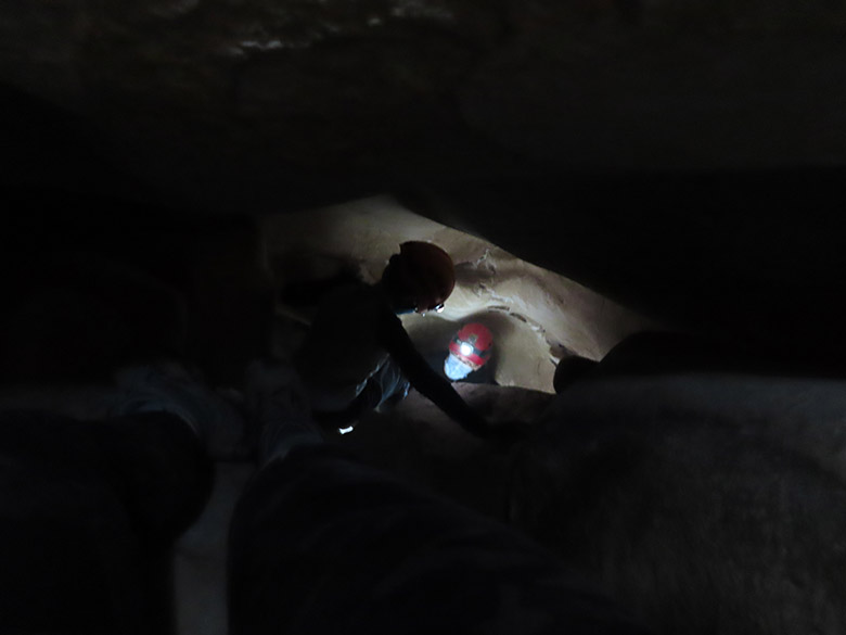
As you inch your way toward Seligman, you will go through another small town called Peach Springs. This is the location of Grand Canyon Caverns – arguably the coolest and most adventurous Route 66 activity that we did on our Arizona trip. Situated 210 feet below the surface, the caverns came to be after years of erosion from sulfuric acid that had mixed with water following nearby volcanic activity.
Unlike other caves I have visited around the world, Grand Canyon Caverns are completely dry. In fact, they are the largest dry caverns in the U.S. Because they are dry, there are no stalactites or stalagmites to marvel at. But, reciprocally, you don’t have to worry about coming across any mammals, reptiles, or creepy crawlies either. What you will find is a reconstructed giant prehistoric sloth. It turns out this gal’s 11,000-year-old skeletal remains were discovered below a natural entrance.
There are a couple of ways you can tour the caverns. The first is by a guided walk path that will take you past the remnants of a fallout shelter created during the 1962 Cuban Missile Crisis. Or you can do what we did, and select an explorer’s tour that will take you off trail and have you climbing and squeezing your way through several narrow rock tunnels and holes into a series of much smaller caves. The activity is physically challenging, but completely unique. Although I don’t recommend it for anyone who is claustrophobic, or doesn’t like to get dirty.
Seligman
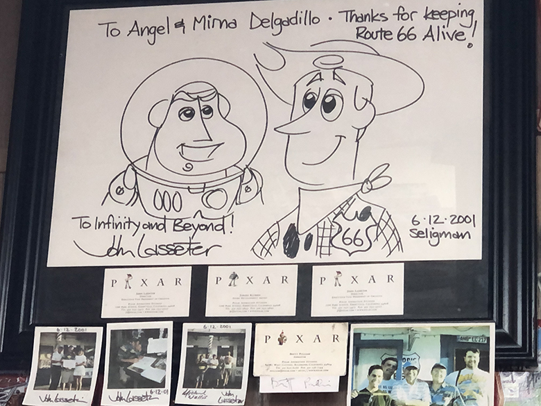
Seligman had a population of 776 in 2019, so don’t expect to find a ton of places to visit along its main street on West Historic Route 66. However, a stop at Angel & Vilma Delgadillo’s Original Route 66 Gift Shop is a must if you want to honor the man who rallied local residents to petition Arizona to make Route 66 a historic highway. Inside you will not only find plenty of Route 66 goodies to purchase, but also a homage to Angel’s old barbershop. And, if you look above the cashier desk, you will see a special note that John Lasseter wrote after he interviewed Angel as part of his Cars movie research.
Also in Seligman is the popular “You kill it, We grill it” Road Kill Café. My kids loved the imaginatively named menu items, but were relieved that they didn’t have to eat squirrel, or other road kill.
Williams
Williams is a charming historic town just outside of Flagstaff with two main streets – one eastbound, one westbound. It is known for the Bearizona Wildlife Park, as well as the Grand Canyon Railway, which takes passengers by steam train into Grand Canyon National Park. Williams was also the last Arizona town along Route 66 to be bypassed by the I-40.
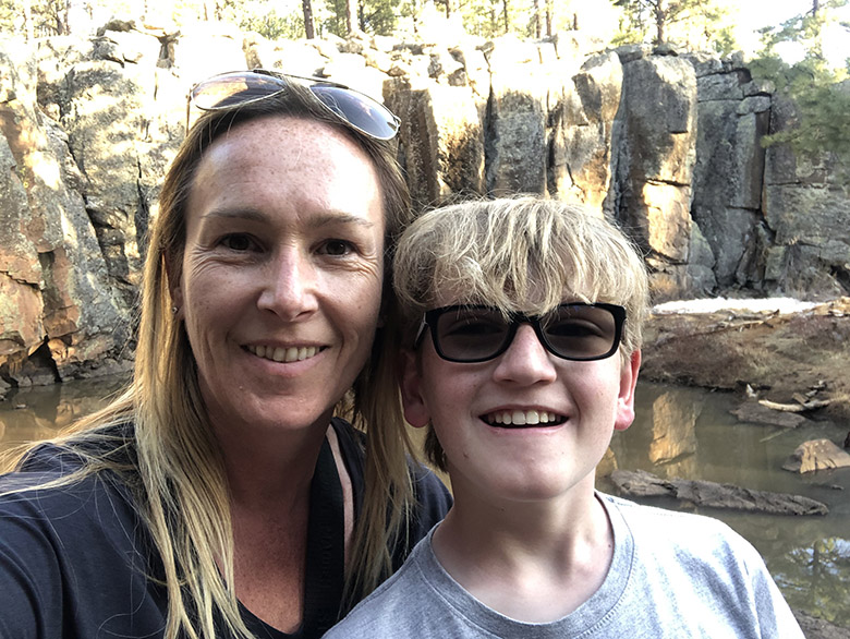
However, my stop here focused on hiking the nearby Keyhole Sink trail in the Kaibab National Forest to find petroglyphs. To get to the trail, you first need to make your way to the Oak Hill Snow Play Area where you will find parking. From there, cross to the other side of Route 66 to get to the trail head.
The hike is great for kids because it is mostly flat and relatively short. It is also easy to follow; with blue cross-country triangles guiding the way. As you meander through the pine trees, be on the lookout for wildlife. When we were there, we found a fresh bear track on route. Toward the end of the trail, you will follow an outcropping of rock around a slight bend. Then you will encounter a latched gate. Go through this gate and make your way into the box canyon, toward a large pond. On the left are a series of large boulders. If you climb these boulders, you will find some great petroglyphs carved into the canyon’s volcanic basalt walls. It is said that these drawings were made about 1,000 years ago by the ancient Cohonina people.
Grand Canyon
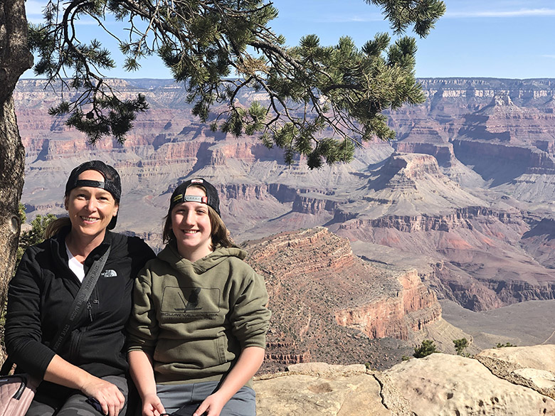
While the Grand Canyon isn’t technically along Route 66, its close proximity means it is hard to justify a trip to this part of Arizona without making a stop at the national park. If you read my earlier Grand Canyon blog, you will know that there are several ways to enjoy the Grand Canyon with kids. When it comes to the South Rim, which is close to Flagstaff, these include hiking the Bright Angel Trail, taking a leisurely walk along the Rim Trail, taking a 3-hour mule ride, or exploring by bike or bus. But, even if you only have an hour or two to spare, it is well worth driving beyond Route 66 to see this magnificent rock formation. After all it is one of the 7 natural wonders of the world!
Flagstaff
Flagstaff is one of those city’s that has more to it than what you see at the surface. A vibrant college town, modern day living is juxtaposed against the remains of its Atlantic and Pacific Railroad past. The Flagstaff Visitor Center in the Historic Train Station offers a number of free guides, including a Walking Guide that will take you around Flagstaff’s historic downtown buildings, and another, called Walk this Talk, that allows you to turn your phone into a tour guide.
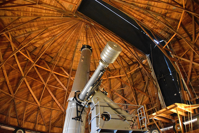
However, for any space enthusiasts, it is the Lowell Observatory that you need to check out. It was here that Neil Armstrong trained for the moon landing, and the dwarf planet Pluto was discovered. Visitors can take in distant stars, planets and galaxies on both modern equipment and some of the observatory’s original telescopes. There is even a new Giovale Open Deck Observatory for solar observing during the day.
Slide Rock State Park
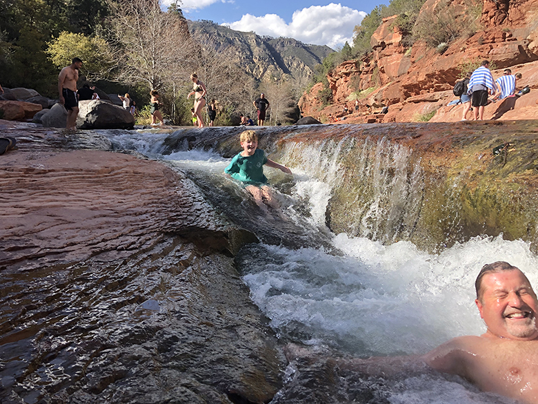
A 20-mile detour south from Flagstaff, after a scenic drive called Oak Creek Canyon, is Slide Rock State Park. This former apple orchard farm has been a popular recreation spot for families, ever since it was bought by the state in 1985. But it isn’t apples that entice visitors. It is the natural waterslides in Oak Creek. Your kids will be so hooked on sliding down the smooth rock channels, that you will easily spend a few hours here. My suggestion would be to make a half day of it by bringing a picnic. Although there is a small market onsite where you can purchase snacks and ice creams.
Montezuma Castle National Monument
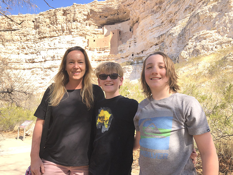
An hour’s drive further south will take you to Montezuma Castle. Unlike any other “castle” you will have seen, these rock dwellings were built into a towering limestone cliff recess by the Sinagua people around 1100 and 1300. The indigenous people who lived here were farmers who took advantage of a nearby limestone sink with continuously flowing springs. They used this water to irrigate crops, and you can even see traces of the lime-coated irrigation ditches that they once used.
For children, the sheer scale and unusualness of this dwelling is what will fascinate them. The five-story structure sits 100 feet above the valley floor and resembles a 20-room apartment building. Which is crazy when you think how old it is. A few feet away is a second structure, called Castle A. This was once even bigger, but is now badly deteriorated. However, a scaled model of Montezuma, toward the end of the tour loop, gives a great overview of what life would have been like here for the Southern Sinagua people.
Happy Travels!
love following your adventures
Cool springs helps me see how CA Adventure was formed with Lightening Mac Queen !